|
INTRODUCTION This chapter introduces the various classifications of airspace and provides information on the requirements to operate in such airspace. Further information can be found in the Aeronautical Information Manual. The two categories of airspace are: regulatory and nonregulatory. Within these two categories there are four types: controlled, uncontrolled, special use, and other airspace. Figure 7-1 presents a profile view of the dimensions of various classes of airspace. Figure 7-2 gives the basic weather minimums for operating in the different classes of airspace. Figure 7-3 lists the operational and equipment requirements. It will be helpful to refer to these figures as this chapter is studied. Also there are excerpts from sectional charts in Chapter 8, Navigation, that will show how airspace is depicted. CONTROLLED AIRSPACE Controlled airspace is a generic term that covers the different classifications of airspace and defined dimensions within which air traffic control service is provided in accordance with the airspace classification. Controlled airspace consists of:
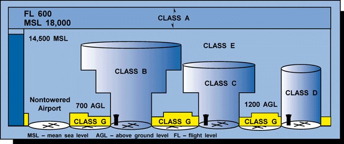
Class A Airspace Class A airspace is generally the airspace from 18,000 feet mean sea level (MSL) up to and including FL600, including the airspace overlying the waters within 12 nautical miles (NM) of the coast of the 48 contiguous United States and Alaska. Unless otherwise authorized, all operation in Class A airspace will be conducted under instrument flight rules (IFR). Class B Airspace Class B airspace is generally the airspace from the surface to 10,000 feet MSL surrounding the nation's busiest airports. The configuration of Class B airspace is individually tailored to the needs of a particular area and consists of a surface area and two or more layers. Some Class B airspace resembles an upside-down wedding cake. At least a private pilot certificate is required to operate in Class B airspace; however, there is an exception to this requirement. Student pilots or recreational pilots seeking private pilot certification may operate in the airspace and land at other than specified primary airports within the airspace if they have received training and had their logbook endorsed by a certified flight instructor in accordance with 14 CFR part 61. Class C Airspace Class C airspace generally extends from the surface to 4,000 feet above the airport elevation surrounding those airports having an operational control tower, that are serviced by a radar approach control, and with a certain number of IFR operations or passenger enplanements. This airspace is charted in feet MSL, and is generally of a 5 NM radius surface area that extends from the surface to 4,000 feet above the airport elevation, and a 10 NM radius area that extends from 1,200 feet to 4,000 feet above the airport elevation. There is also an outer area with a 20 NM radius which extends from the surface to 4,000 feet above the primary airport and this area may include one or more satellite airports. Class D Airspace Class D airspace generally extends from the surface to 2,500 feet above the airport elevation surrounding those airports that have an operational control tower. The configuration of Class D airspace will be tailored to meet the operational needs of the area.
Figure 7-2. -- Visual flight rule weather minimums.
Figure 7-3. -- Requirements for airspace operations.
Class E Airspace Class E airspace is generally controlled airspace that is not designated A, B, C, or D. Except for 18,000 feet MSL, Class E airspace has no defined vertical limit, but rather it extends upward from either the surface or a designated altitude to the overlying or adjacent controlled airspace. UNCONTROLLED AIRSPACE Class G Airspace Uncontrolled airspace or Class G airspace is the portion of the airspace that has not been designated as Class A, B, C, D, or E. It is therefore designated uncontrolled airspace. Class G airspace extends from the surface to the base of the overlying Class E airspace. Although air traffic control (ATC) has no authority or responsibility to control air traffic, pilots should remember there are VFR minimums which apply to Class G airspace. S PECIAL USE AIRSPACE Special use airspace exists where activities must be confined because of their nature. In special use airspace, limitations may be placed on aircraft that are not a part of the activities. Special use airspace usually consists of:
Prohibited Areas Prohibited areas are established for security or other reasons associated with the national welfare. Prohibited areas are published in the Federal Register and are depicted on aeronautical charts. Restricted Areas Restricted areas denote the existence of unusual, often invisible hazards to aircraft such as artillery firing, aerial gunnery, or guided missiles. An aircraft may not enter a restricted area unless permission has been obtained from the controlling agency. Restricted areas are depicted on aeronautical charts and are published in the Federal Register. Warning Areas Warning areas consist of airspace which may contain hazards to nonparticipating aircraft in international airspace. The activities may be much the same as those for a restricted area. Warning areas are established beyond the 3-mile limit. Warning areas are depicted on aeronautical charts. Military operation areas (MOA) consist of airspace of defined vertical and lateral limits established for the purpose of separating certain military training activity from IFR traffic. There is no restriction against a pilot operating VFR in these areas; however, a pilot should be alert since training activities may include acrobatic and abrupt maneuvers. MOAs are depicted on aeronautical charts. Alert Areas Alert areas are depicted on aeronautical charts and are to advise pilots that a high volume of pilot training or unusual aerial activity is taking place. Controlled Firing Areas Controlled firing areas contain activities, which, if not conducted in a controlled environment, could be hazardous to nonparticipating aircraft. The difference between controlled firing areas and other special use airspace is that activities must be suspended when a spotter aircraft, radar, or ground lookout position indicates an aircraft might be approaching the area. National Security Areas National security areas consist of airspace of defined vertical and lateral dimensions established at locations where there is a requirement for increased security and safety of ground facilities. Pilots are requested to voluntarily avoid flying through these depicted areas. When necessary, flight may be temporarily prohibited. OTHER AIRSPACE AREAS "Other airspace areas" is a general term referring to the majority of the remaining airspace. It includes:
Airport Advisory Areas An airport advisory area is an area within 10 SM of an airport where a control tower is not operating, but where a flight service station (FSS) is located. At these locations, the FSS provides advisory service to arriving and departing aircraft. Military Training Routes Military training routes (MTR) are developed to allow the military to conduct low-altitude, high-speed training. The routes above 1,500 feet AGL are developed to be flown primarily under IFR, and the routes 1,500 feet and less are for VFR flight. The routes are identified on sectional charts by the designation "instrument (IR) or visual (VR)." Temporary Flight Restrictions Temporary flight restrictions are established, when required, to protect persons and property in the air or on the surface. The intent of these restrictions is to provide a safe environment for relief or rescue aircraft, eliminate congestion which might occur in airspace over special events, protect airspace in the vicinity of presidential flights, etc. Many times the FSS coordinates temporary flight restrictions, and when necessary, a Notice to Airmen is issued. Parachute Jump Areas Parachute jump areas are published in the Airport/Facility Directory. Sites that are used frequently are depicted on sectional charts. Published VFR Routes Published VFR routes are for transitioning around, under, or through some complex airspace. Terms such as VFR flyway, VFR corridor, Class B airspace, VFR transition route, and terminal area VFR route have been applied to such routes. These routes are generally found on VFR terminal area planning charts.
|
|||||||||||||||||||||||||||||||||||||||||||||||||||||||||||||||||||||||||||||||